This page is for US Highways, marked by a
For
For
For
| Route | Map | State | Start | End | Note |
|---|---|---|---|---|---|
| 1 | 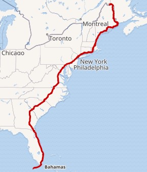 |
ME, NH, MA, RI, CT, NY, NJ, PA, MD, DC, VA, NC, SC, GA, FL | Fleming and Whitehead streets in Key West, FL | Canadian border at Fort Kent, ME | Follows the East Coast of the United States |
| 2 | 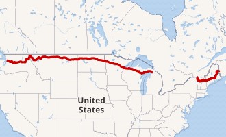 |
ME, NH, VT, NY, MI, WI, MN, ND, MT, ID, WA | I-5/SR 529 in Everett, WA | I-75 in St. Ignace, MI | Western segment |
| 3 | 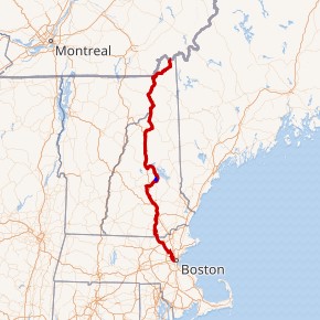 |
NH, MA | Route 2A/Route 3 in Boston, MA | Canadian border at Pittsburg, NH | Massachusetts signs the southern end in Cambridge, northeast of AASHTO's end |
| 9 | 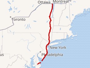 |
NY, NJ, DE | US 13 in Laurel, DE | I-87 at Champlain, NY | Route includes Cape May–Lewes Ferry across the Delaware Bay; New York signs the northern end at a dead-ending parking lot just south of the border crossing |
| 10 | 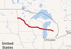 |
MN, WI, MI | I-94/BL I-94/US 52 in West Fargo, ND | I-75/BL I-75/US 23/M-25 near Bay City, MI | Route includes a ferry across Lake Michigan |
| 13 | 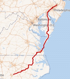 |
PA, DE, MD, VA, NC | I-95/I-295 northeast of Fayetteville, NC | US 1 in Morrisville, PA | Pennsylvania signs the northern end at US 1, just south of AASHTO's end |
| 20 |  |
OR, ID, MT, WY, NE, IA, IL, IN, OH, PA, NY, MA | US 101 in Newport, OR | Yellowstone National Park, WY | Yellowstone National Park, MT | Route 2 in Boston, MA | Segments connected by road through Yellowstone National Park |
| 23 | 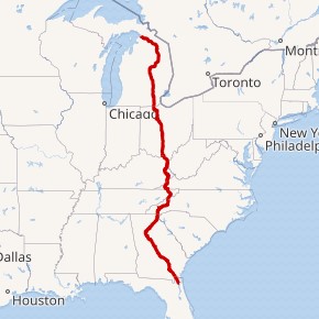 |
FL, GA, NC, TN, VA, KY, OH, MI | US 1, US 17 in Jacksonville, FL | I-75 in Mackinaw City, MI | Michigan signs the northern end where it merges with I-75, while AASHTO continues it north to the southern end of the Mackinac Bridge |
| 30 | 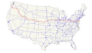 |
OR, ID, WY, NE, IA, IL, IN, OH, WV, PA, NJ | US 101 in Astoria, OR | Absecon Boulevard and Virginia Avenue in Atlantic City, NJ | A majority of the historic Lincoln Highway, the first road across America, became US Route 30, from Philadelphia PA to Granger WY. |
| 31 | 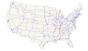 |
AL, TN, KY, IN, MI | US 90, US 98, SR 16 in Spanish Fort, AL | I-75 south of Mackinaw City, MI | Michigan signs the northern end where it merges with I-75, while AASHTO continues it north to the southern end of the Mackinac Bridge |
| 35 | 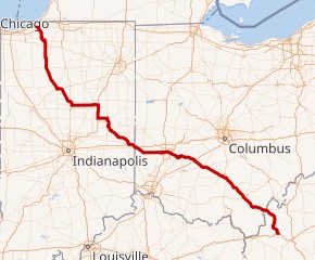 |
IN, OH, WV | I-64 in Teays Valley, WV | US 20 in Michigan City, IN | Indiana signs the northern end at US 12 |
| 40 | 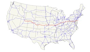 |
UT, CO, KS, MO, IL, IN, OH, WV, PA, MD, DE, NJ | I-80, US 189 north of Park City, UT | US 322 in Atlantic City, NJ | Replaced by I-80 between San Francisco, CA and US 189 north of Park City, UT |
| 42 | 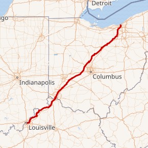 |
OH, KY | US 31E, US 60 in Louisville, KY | US 6, US 20, US 322, US 422 in Cleveland, OH | Kentucky signs the western end of US 42 at US 31E/US 60, just west of I-65 |
| 43 | 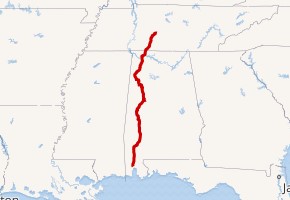 |
TN, AL | US 31, US 45, US 90 in Mobile, AL | US 31 in Columbia, TN | Alabama signs the southern end at US 90 north of downtown Mobile |
| 45 |  |
AL, MS, TN, KY, IL, WI, MI | US 31, US 43, US 90 in Mobile, AL | River and Ontonagon streets in Ontonagon, MI | Alabama signs the southern end at US 98 west of downtown Mobile |
| 46 | 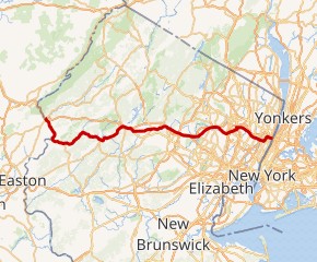 |
NJ | I-80/Route 94 in Columbia, NJ | I-95, US 1, US 9 at the Hudson River in Fort Lee, NJ | Intrastate, New Jersey only |
| 48 | 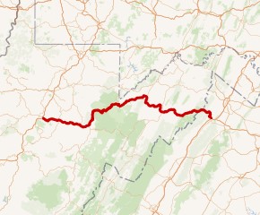 |
WV, VA | I-79, US 33, US 119 east of Weston, WV | I-81 north of Strasburg, VA | Temporary route for Corridor H |
| 54 | 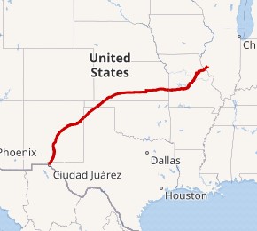 |
TX, NM, OK, KS, MO, IL | Loop 375 in El Paso, TX | I-72/US 36/IL 107 near Griggsville, IL | Texas signs the western end at a point east of the border crossing |
| 56 |  |
KS, OK, NM, TX | I-25 Bus./US 412/NM 21 in Springer, NM | US 71 in Kansas City, MO | Mostly follows the Santa Fe Trail and Cimarron Cutoff |
| 57 | 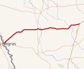 |
TX | Mexican border at Eagle Pass, TX | I-35 southwest of Moore, TX | Intrastate, Texas only |
| 62 | 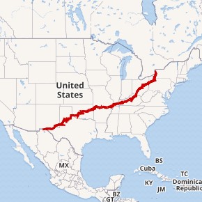 |
TX, NM, OK, AR, MO, IL, KY, OH, PA, NY | US 85 in El Paso, TX | Canadian border at Niagara Falls, NY | New York signs the northern (eastern) end in Niagara Falls, northeast of the border crossing |
| 65 | 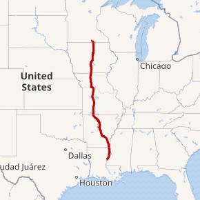 |
MN, IA, MO, AR, LA | US 425 in Clayton, LA | I-35 in Albert Lea, MN | Minnesota signs the northern end at I-35 south of I-90 |
| 72 | 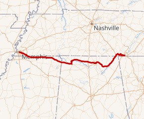 |
TN, AL, MS | US 64/US 70/US 79 in Memphis, TN | US 11/US 41/US 64/US 76 in Chattanooga, TN | Only non-intrastate highway to have its termini in the same state |
| 79 | 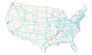 |
TX, LA, AR, TN, KY | I-35 in Round Rock, TX | US 68 in Russellville, KY | Texas signs the southern end at I-35 at Round Rock, north of Austin |
| 89 | 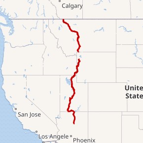 |
MT, WY, ID, UT, AZ | US 180 in Flagstaff, AZ | Yellowstone National Park, MT near Gardiner, MT | Yellowstone National Park, WY | Canadian border near Babb, MT | Segments connected by road through Yellowstone National Park |
| 90 |  |
TX, LA, MS, AL, FL | I-10 in Van Horn, TX | SR A1A in Jacksonville Beach, FL | Follows the Gulf Coast of the US |
| 92 | 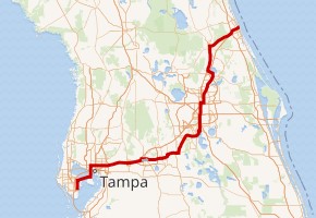 |
FL | I-175, I-375, SR 687 in St. Petersburg, FL | SR A1A in Daytona Beach, FL | Intrastate, Florida only |
| 96 | 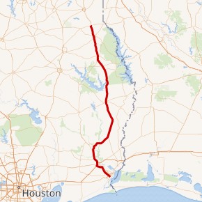 |
TX | US 69/US 287/TX 87 in Port Arthur, TX | US 59, US 84 in Tenaha, TX | Intrastate, Texas only |
| 98 | 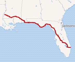 |
MS, AL, FL | US 61, US 84, US 425 in Natchez, MS | US 1 in West Palm Beach, FL | Mississippi records indicate the western end is at US 84 in Bude, although there are US 98 shields as far west as Natchez. Florida signs US 98 east of US 1, ending at SR A1A. |
| 101 | 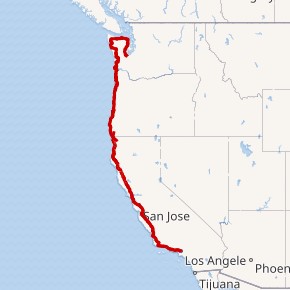 |
WA, OR, CA | I-5 in Los Angeles, CA | I-5 in Olympia, WA | Follows the West Coast of the United States |
| 117 | 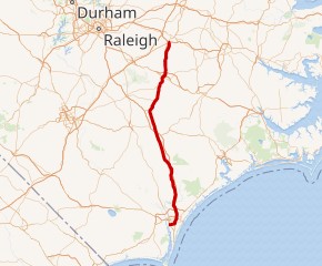 |
NC | Port of Wilmington at Wilmington, NC | I-95, US 264 west of Wilson, NC | Intrastate, North Carolina only |
| 121 | 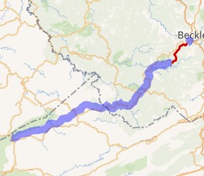 |
VA, WV | US 23 in Pound, VA | I-64, I-77 in Beckley, WV | Proposed highway |
| 127 | 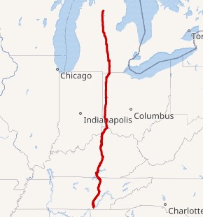 |
MI, OH, KY, TN | US 11, US 64, US 72 in Chattanooga, TN | I-75 south of Grayling, MI | Tennessee signs the southern end at US 27 north of Chattanooga |
| 130 | 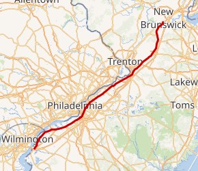 |
NJ | I-295, US 40 southwest of Penns Grove, NJ | US 1 southwest of New Brunswick, NJ | Intrastate, New Jersey only |
| 136 | 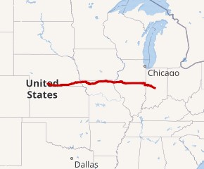 |
NE, MO, IL, IN | US 6, US 34 north of Edison, NE | I-465/I-74 west of Indianapolis, IN | Formerly continued into Indianapolis to end at US 421 |
| 158 | 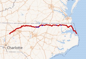 |
NC | US 64, US 601 in Mocksville, NC | US 64 south of Nags Head, NC | Intrastate, North Carolina only |
| 171 | 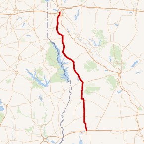 |
LA | US 90 in Lake Charles, LA | US 79, US 80 in Shreveport, LA | Intrastate, Louisiana only |
| 175 | 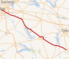 |
TX | US 69 in Jacksonville, TX | SH 310 in Dallas, TX | Intrastate, Texas only; Texas signs the western (northern) end at I-45 north of AASHTO's end |
| 181 | 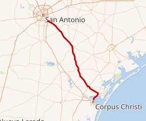 |
TX | I-37 in Corpus Christi, TX | I-35, US 281 in San Antonio, TX | Intrastate, Texas only; Texas signs the northern end at I-37 southeast of San Antonio |
| 189 |  |
UT, WY | I-15 in Provo, UT | US 26, US 89, US 187, US 191 in Jackson, WY | Utah does not sign US 189 north of US 40 at Heber City |
| 191 | 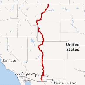 |
MT, WY, UT, AZ | Mexican border at Douglas, AZ | Yellowstone National Park, MT near West Yellowstone, MT | Yellowstone National Park, WY | Canadian border near Loring, MT | Segments connected by road through Yellowstone National Park |
| 192 | 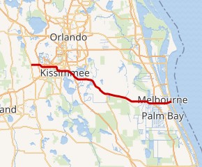 |
FL | US 27 near Four Corners, FL | SR A1A in Indialantic, FL | Intrastate, Florida only |
| 201 | 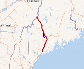 |
ME | US 1 in Brunswick, ME | Canadian border near Saint-Theophile, QC | Intrastate, Maine only |
| 202 | 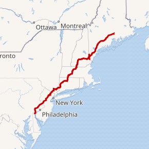 |
ME, NH, MA, CT, NY, NJ, PA | US 13, US 40 northwest of New Castle, DE | US 1 Alt., I-395 in Bangor, ME | Maine signs the northern end at US 2 in Bangor |
| 211 | 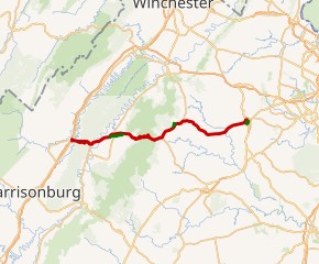 |
VA | I-81 in New Market, VA | US 15 Bus., US 29 Bus. in Warrenton, VA | Intrastate, Virginia only |
| 223 | 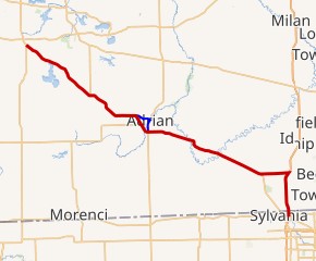 |
MI, OH | US 23, SR 51/SR 184 in Sylvania, OH | US 127 west of Somerset, MI | Ohio does not sign the designation |
| 264 | 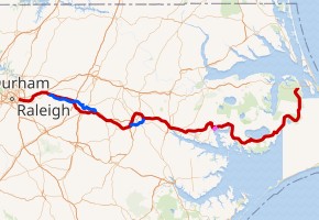 |
NC | I-440, US 64 in Raleigh, NC | US 64 southwest of Nags Head, NC | Intrastate, North Carolina only |
| 266 | 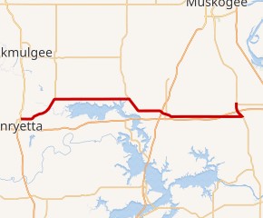 |
OK | US 62, US 75 in Henryetta, OK | US 64 in Warner, OK | Intrastate, Oklahoma only |
| 287 | 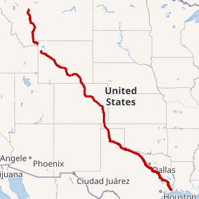 |
MT, WY, CO, OK, TX | US 69/US 96/TX 87 in Port Arthur, TX | Yellowstone National Park, MT | Yellowstone National Park, WY | US 89 in Choteau, MT | Segments connected by road through Yellowstone National Park |
| 290 | 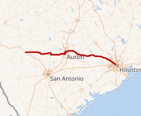 |
TX | I-10 near Harper, TX | I-610 northwest of Houston, TX | Intrastate, Texas only |
| 302 | 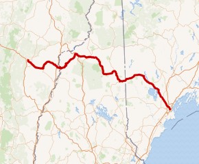 |
VT, NH, ME | US 2 in Montpelier, VT | I-295, US 1 in Portland, ME | Maine signs the eastern end along US 1 several blocks south of I-295 |
| 310 | 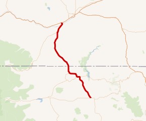 |
MT, WY | US 14, US 16, US 20 in Greybull, WY | I-90, US 212 in Laurel, MT | Wyoming signs the eastern (southern) end where AASHTO has it join US 14/US 16/US 20 west of Greybull |
| 341 | 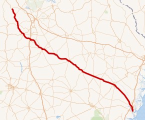 |
GA | US 17 in Brunswick, GA | US 41 in Barnesville, GA | Intrastate, Georgia only |
| 350 | 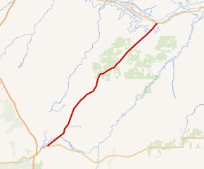 |
CO | I-25, US 85, US 87, US 160 in Trinidad, CO | US 50 in La Junta, CO | Intrastate, Colorado only; Colorado signs the western end at US 160 northeast of Trinidad |
| 360 | 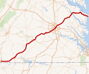 |
VA | US 58 Bus. in Danville, VA | Main Street/Reed Ave. in Reedville, VA | Intrastate, Virginia only |
| 377 | 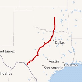 |
TX, OK | US 90, US 277 in Del Rio, TX | US 70 in Madill, OK | Oklahoma signs the northern end at I-44 at Stroud |
| 441 | 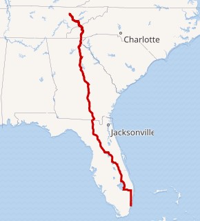 |
TN, NC, GA, FL | US 27 in Miami, FL | US 25W in Lake City, TN | Florida signs the southern end at US 41 |
| 491 | 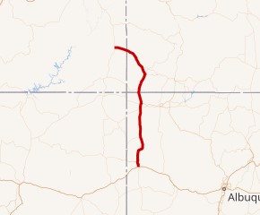 |
UT, CO, NM | I-40 in Gallup, NM | US 191 in Monticello, UT | Result of a renumbering of US Route 666 |